Weather Underground Radar. - For the Sterling and metropolitan area. Composite and Reflectivity are available with the use of filter controls.
Weather Underground. - US temperature chart 6 hour loop. Chart updated 4 times daily Click on your state for local weather station information.
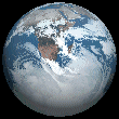
Unisys Weather. - These images are generated by geostationary satellites orbitting 22,000 miles above the equator looking at the United States. These images updated once an hour at about 30 after the hour.
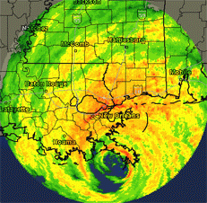
National Hurricane Center. - The 2012 Atlantic hurricane season ends November 1, with officials warning of a busy year. Click here for the latest updates and positions.
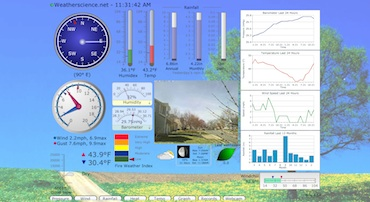
Weatherscience.net Cam - *new* Live feed
from our Roof Cam located at our Weatherscience.net studio. Click on the image to see a loop over the past 24 hours. Click here. to see a live feed.
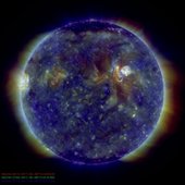
SpaceWeather.com. - A great place to find out about space weather and its effects on our planet. Get up to date information on auroras, solar flares, and meteor showers. Click here to get the latest SDO images or here for data from SolarSoft
LightningFinder.com Real time lightning data updated every 30 seconds. Downlaod the app for iPhone and Ipad.
About Earth's Weather. - Take a look in to the forces that affects and makes up earth's weather. Special thanks to Lisa Gardiner.
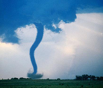
Tornado Chasers. - Weather related news pertaining to tornados as well as safety information on how to prepare for one in case one strikes in your area.
Eumetcast of Metop-2. - Images of Metop-2 are provided by Eumetsat and are updated every 3 minutes. To access EPS flight IR 10.8 clickhere.
NOAA Weather Radio. - Broadcast live over the web. Catch weather warnings and severe weather alerts.
Operations information and Special Events
Office of Satellite Operations Daily Satellite Status Report - On 10/18/2012 GOES-13 returned to service following an anomoly with the Sounder instrument that involved the filter wheel lubricant. After two weeks of of outgassing the noise levels returned to normal limits
Real Time Satellite Tracking - NOAA and other satelltes. Custom groups of satellites can be configured and tracked. Go to the main page to setup your location. Update 11/05/09: Russian weather satellite Meteor 1M has now been added.
Eumetsat Mission website - UPDATE 10/18/2012: Following a successful launch on September 17 and handover to EUMETSAT from ESA/ESOC, on 20 September, Metop-B is now in commissioning.
Key milestones for the post-launch commissioning phase, including details on when instruments are switched on and tested, and when data starts to become available for users
NASA Website - Update 10/15/2012: Commands will be sent to Curiosity today instructing the rover to collect a third scoop of soil from the "Rocknest" site of windblown Martian sand and dust. Pending evaluation of this Sol 69 (Oct. 15, 2012) scooping, a sample from the scoopful is planned as the first sample for delivery -- later this week -- to one of the rover's internal analytical instruments, the Chemistry and Mineralogy (CheMin) instrument
Photo of the Week - 10/16/2012: From the Capital Weather Gang Fireball!!! Several folks in the DC, Maryland, Va. region report seeing a fireball streak through the sky around 7 pm last night (just before the presidential debate, coincidence?). Did you see it?. If you have a great weather or nature photo please email it to Webmaster@weatherscience.net and we will showcase it on our site.


